| Bacolod City, Philippines | Tuesday, December 11, 2012 |
| Front Page | |||||||
| Negros Oriental | |||||||
| Star Business | |||||||
| Opinion | |||||||
| Sports | |||||||
| Police Beat | |||||||
| Star Life | |||||||
| People & Events | |||||||
|
|||||||

 | Opinion Columns | |||||
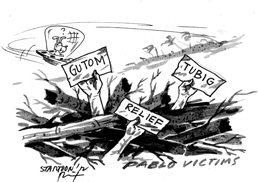
| Use those geo-hazard maps
One thing that typhoon “Pablo” proved once again, is that the geo-hazard maps that were painstakingly generated and distributed to local governments by the Mines and Geosciences Bureau of the Department of Environment and Natural Resources, are indeed critical tools that government officials and private citizens should pay attention to. Senator Loren Legarda, chairperson of the Senate Committee on Climate Change, stressed the importance of disseminating, using, heeding and updating those geo-hazard maps to avoid exposing communities to disasters. Sen. Legarda made the call following reports that geo-hazard maps, which showed that many parts of Compostela Valley were shaded in red, meaning those areas are highly susceptible to landslides, were ignored. The maps had been released to the areas by the MGB way back in 2006, and obviously from the affected areas nobody bothered to check with the maps and interpret the danger that it warned about and ultimately foretold. So when Typhoon Pablo tore through the area last week, the scientists were proven right and the town of New Bataan in Compostela Valley, which is shaded in purple in the geo-hazard maps, meaning no-man’s land or permanent danger zones where human settlement should not be allowed because of “very high” susceptibility to landslides, suffered the highest number of casualties. While their area may have been mercifully spared from typhoons for decades, they should have paid heed to the warning signs over the past few years of a changing climate, and given those geo-hazard maps a second look, even if it was just after they were informed that a super typhoon was coming their way. The relevance and the accuracy of the geo-hazard maps were highlighted last year, when Typhoon Sendong tore through the vulnerable sections of Cagayan De Oro, killing almost 1,500. Despite that harrowing experience, Typhoon Pablo has made it clear that many local officials continue to ignore those maps. Will those of us, who have been fortunate enough to have been spared from powerful typhoons for two straight years, wait until our luck has run out before we consult those maps? We certainly hope not.* | ||||||